
Search history
Clear allSearch by image
XDrag and drop an image here or upload an image
Max 5MB per image
UploadSign In | Join
Search history
Clear allSearch by image
XDrag and drop an image here or upload an image
Max 5MB per image
UploadSign In | Join
X Email Mobile
Shenzhen Guoan Equipment Co., Ltd. 13yr.
Contacts:汪林华 Chat
Mobile:86-13689534075
E-mail:1004808756@qq.com
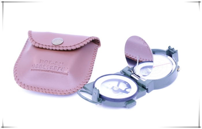
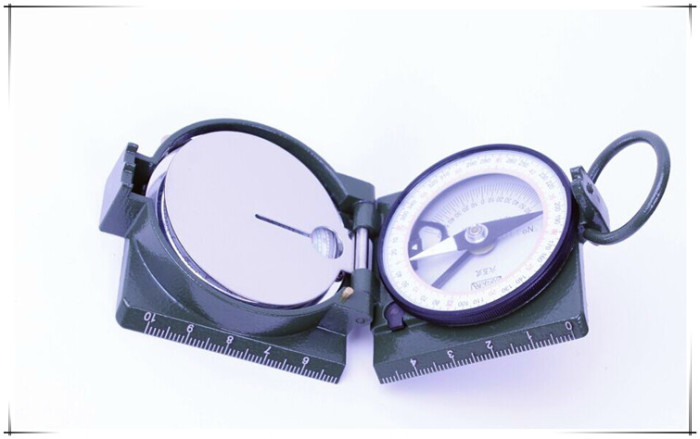
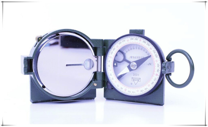
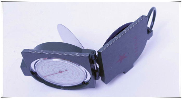
Type DQL-5 65 type geological compass .
the products are mainly used in the determination of position, distance, level, slope (elevation angle), height, speed, time marching and mapping simple map.
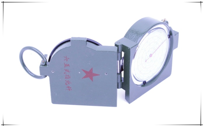
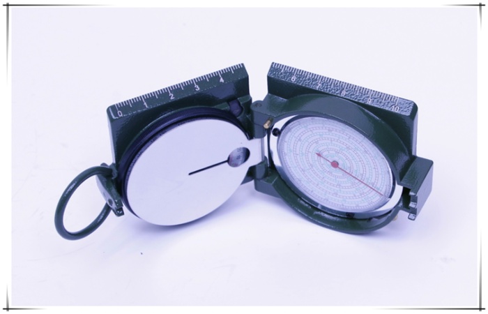
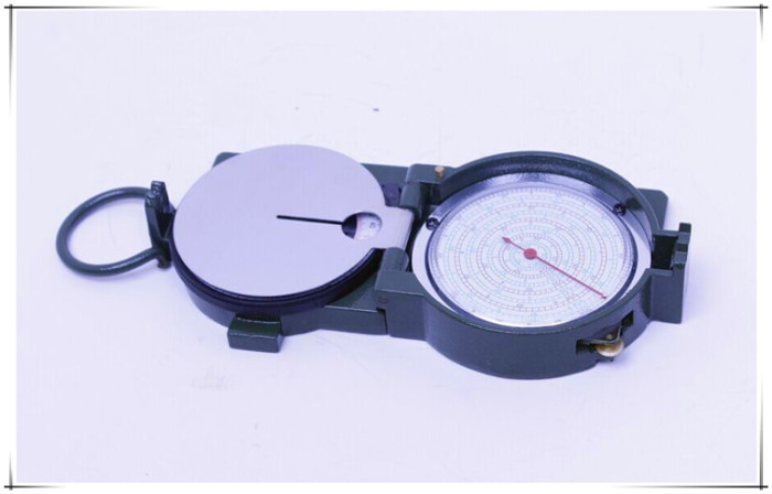
compass and odometer instrument is mainly composed of two parts, such as (Figure 1). Some compass to ring 1, dial 2, in the dial seat row has two lines, the outer ring is the division of 360 degree system, each line is 1 degrees. The inner ring (6000 mil) reticle system, are engraved with 300 lines, each line value of 20 (MIL). There are 3 needle, 4 goniometer. The pitch angle of the dividing unit, each line is 2.5 degrees, can measure the pitch angle of 60 degrees. The odometer is mainly composed of the mileage meter, the speed schedule 8, the measuring wheel 9, the gear, the pointer and so on. Mileage Division has 1:50000, 1:100000 two scale scale value. 1:100000 scale of each corresponding line on behalf of 1 kilometers, 0.5 kilometers each line represents 1:50000, can be used in conjunction with the corresponding proportion or double the proportion of map. Speed schedule Division: the outer dial has 13, 15, 17, 19, 21, 23, 25 km / h, the inside dial has a number of 10, 14, 16, 18, 20, 22, 30 km / h. (represented by V), a total of fifteen speeds. The time scale in each corresponding line represents five minutes (V25 10 minutes). The side
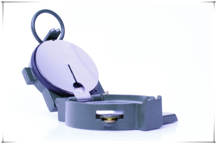
instrument foot, two for distance assessment. It is a two tip length of 12.3 mm, a 123 mm long and sight. 10 times as long as the tip.
The shell is made of aviation magnesium alloy material, high strength, low weight. Color: green
Delta Delta
size: 68mm * 63mm * 26mm
technical parameters
mileagemeasurement ratio: 1:50000,1:100000
goniometer reading error: less than or equal to 1.25 degrees
time speed dial lattice value: 5 min
weight: 0.15kg
Using the method of
(1)
1, the determination of position determination in the southeast northwest
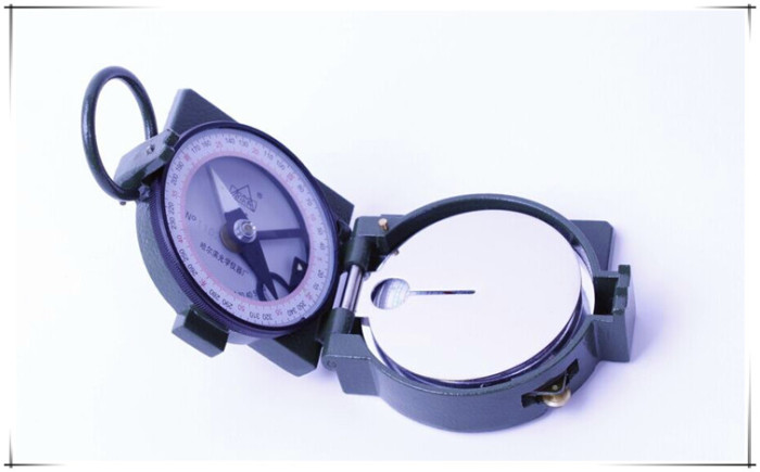
(1) open the compass, the azimuth alignment index "delta" 0 "".
(2) rotating compass needle, to refer to the North alignment after "0", that is referring to the direction of the north. In the range of glass can be directly read the East and south, West and North direction.
2,
calibration calibration map orientation map orientation is the use of compass makes the position on the map and in the same direction.
(1) to open the instrument, adjusting the dial, the range of indicators "delta" area of the alignment degree of declination.
(2) to mapping and map foot the true meridian or coordinates (vertical line profile is something figure profile tangent).
(3) rotation map, the northern tip of needle pointing to "0", the position on the map and the local spaces are exactly the same. The magnetic azimuth
3, determination of magnetic azimuth
A determination of the target map of
angle (1) map with compass calibration accuracy, and keep the real map.
(2) will foot with the point and the target point of tangency, adjusting disc seat, the index of "delta" alignment "0" scoring.
(3) after the needle stationary, its northern end refers to the magnetic azimuth scale is the base point to the target point angle. The magnetic azimuth determination to target the
B angle
(1) open the instrument, the azimuth alignment index "delta" and "0", the reflector and the dial holder slightly to 45 degrees.
(2) ring with the thumb inserted, Ping holding apparatus, from sight to sight of target.
(3) from the reflective mirror at the northern tip of the needle dial pedestal at the division, which is to target the magnetic azimuth angle value.
(two) distance measuring distance
1, with the ruler nomograph on direct mapping. The
2, with pictures on the distance of the distance measurement
(1) the red pointer to "0"; the
(2) Ping holding apparatus, the odometer measuring wheel gently on a starting point, along the route taken by the volume of the roll forward to the end of the
(3;) according to a pointer in the scale on the line, you can directly read out the corresponding distance field. For example, in the 1:50000 map traffic from a point to point B, the instrument on the surface of 1:50000 refers to the scale of 14 lines, distance between two points a and B field is 7 km. If the map in the 1:100000 measured 14 lines a and B, then the distance of 14 kilometers. In addition, a map with a corresponding proportion (e.g., 1:25000) or a plurality of ratios (such as 1:20000 and 1:500000) can also be read by. The
3, in situ determination of target distance assessment approximate distance. The
instrument distance assessment two tip for the sight of the interval and sight distance between 1 / 10, the similar triangle relationship can be determined at the target distance.
(1) the two known target (object) distance and point, for the two target (object) between the interval between the
by the following formula: two target interval = two target and the standing point of the distance between * 1 / 10 *
open instrument, with the eye close to the target a, such as two, object (object) is assessed from the two point clamped, and between the two known target point and point distance of 100 meters, two target points between the interval is 100 * 1 / 10 = 10 meters, the rest can be calculated in this way. The
in front of two target (object) intervals not just distance assessment two point clamped and smaller or larger than the spacing, can use the following formula: multiple the
two target interval = two goals and where the distance between the x 1 / 10 the two X two target tip interval. The
cases: two known target and the standing point of the distance between 100 meters, measured two target intervals for distance assessment two tip interval of 7 / 10, two inter target interval is 100 x 1 / 10 x 7 / 10 = 7 meters. The same
: if the two target interval is 1.5 times the distance assessment two tip interval, two target interval is 100 x 1 / 10 x 1.5 = 15 meters. The
(2) between the two known object width or the distance of the target, find the target point and the distance between the following formula: the
interval distance between the target and the standing point of the known target = x 10
cases: the interval between the two known front target is 12 meters, just as the two point sighting distance assessment, target point and stand up the distance between points is: 12 * 10=120 M. The
in known target intervals, but in sight, less than or greater than two tip distance assessment interval, the following formula can be used: the actual /
the target interval target and point distance = target for multiple distance assessment two tip of the interval between the (* * 10
note: the use of distance assessment method to target distance is simple, but the accuracy is not high. )
(three) determination of the slope of the slope (pitch angle) the
open instrument, make mirror and dial a slightly 45 degrees, the side holding apparatus, to aim at the side slope along the sight, sight, and line of sight parallel with the slope, let freedom swing angle measuring device, from the anti light mirror gaze angle what is the central line indicating scale pitch angle of table partition, shall be for the pitch angle (slope).
(four)
instruments on computing speed schedule marching time and speed, the mileage in volume at the same time, the time required to March can be determined within the specified time or the marching speed, the method is as follows
1, March time calculation: open the instrument, the speedometer pointer to zero (dial on the red line). The destination range at the same time, according to the speed schedule 1:100000 scale mileage, at 13, 15, 17 points, 19, 21, 23, 25 km / hour
(outside the table, clockwise readings) and 10, 14, 16, 18, 20, 22, 24, 30 / km when small (medial table, counterclockwise speed reading) March required time, if the mileage for the amount in the 1:50000 scale map, with a finger flick measuring wheel, so that in the process
halved, indicating the pointer speed and time is required. For example: in the 1:50000 scale on the amount of distance of 40 km, according to the "V20" speed to complete the whole process, the required time. The pointer to 1:50000 scale of 20 km, in the circle of V20
pointer referred to in which the. If the speed of no display speed table, then find out the relationship between the speed ratio, multiplied by the magnification obtained, such as speed of 5 kilometers per hour March, measured mileage of 30 kilometers, for the time, he read: "V10" for 3 small
, because "V10" is V5 the number is 2 times by 2 round or test the pointer indicates 60 kilometers V10 read 6 hours, or "V6", "V18", will be read by 3 or dial test indicator wheel to make 90 kilometers to read "V18" for 5 hours, and so on. So, recently, in the meteorite? Xia did not include marching on you? Rest, adjust and measure the road slope and bending coefficient, in March, should be added to the relevant data in the table).
2, marching speed calculation, calculated on arrival mileage at the same time, according to the requirements of the arrival time, it can speed calculation of time table select the appropriate speed within the time limit prescribed (Note: if the mileage for the 1:50000 scale should be redoubled to choose the required time) as the marching speed.
(five) measuring target height
roughly the known target (object) and the horizontal distance between the point and pitch angle of targets are first determined, and then check the table height, can know the height of the object, the method is as follows: 1,
by map or obtained from the assessment device and point to the target (such as the peak, chimney, spire etc.) the horizontal distance. 2, the
side holding apparatus, aiming to target the top along the sight, sight, let freedom swing angle measuring device to stop, see the pitch angle goniometer with the indicated values. The
3, see table height (Table 1) or with a formula that can highly. The
: Cases of known points to the measured horizontal distance of 100 meters, with the instrument measured pitch angle is 30 degrees, and then check the height alignment table, 30 degrees vertical lattice in 100 meters across, Richard measured height of 57.74 meters.
instrument maintenance
1, do not put the instrument near ferromagnetic material, so as to avoid loss of magnetism. The
2, mapping objects with beating feet, so as not to affect the accuracy of measurement. The
mirror 3, do not twist, so as not to affect the aiming and reading division, keep the surface clean, do not wipe with a dirty cloth, hand.
Update time:


TOP


